News
U.S. Is Backing Anaerobic Digesters. Scientists and Advocates Say Stronger Guardrails Are Needed.
Climate•6 min read
News
Removing the instruments could leave gaps in tracking ocean acidification, climate change and oxygen levels — changes that increasingly affect fisheries.

Words by Gaea Cabico
Update: On June 18, the National Science Foundation announced it would immediately halt plans to shut down four of the five arrays that make up the Ocean Observatories Initiative. This followed a June 17 measure passed by the Senate that prohibited the National Science Foundation from using federal funds to decommission the Ocean Observatories Initiative’s instruments.
“While the Endurance Array has been removed from the water, we are developing plans to redeploy the equipment after servicing,” the agency said in a statement. NSF will also gather feedback from stakeholders and convene an expert panel to “help the agency identify a sustainable path” for its ocean observing systems.
For years, scientists and commercial fishers have relied on a network of underwater instruments to track ocean temperature, acidity, oxygen levels and other changes affecting marine life in real time. Now, as fisheries across the country grapple with warming waters and ocean acidification, the Trump administration is dismantling most of that critical monitoring system.
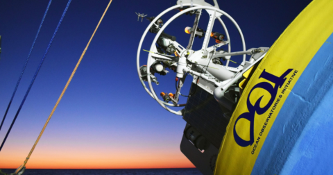
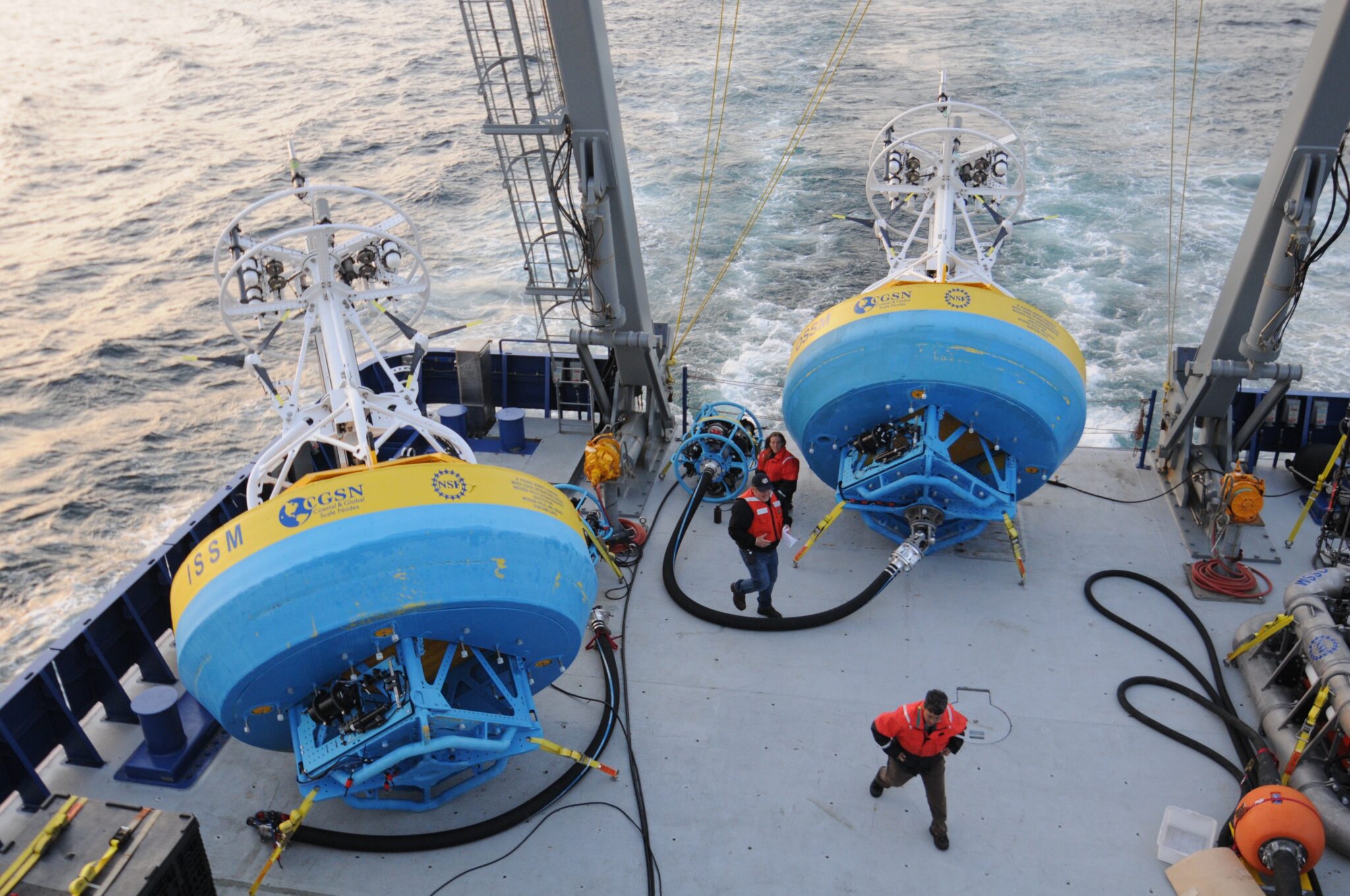
On May 21, the National Science Foundation announced it would shut down four of the five arrays that make up the Ocean Observatories Initiative, a $368 million network of approximately 900 instruments that has tracked changes in the ocean’s biological, chemical and physical conditions since 2016. This would remove monitoring infrastructure from the East Coast, the Pacific Northwest and Alaska — important fishing regions that between them support dozens of marine species that are either currently or historically overfished.
The decision could have far-reaching consequences for fisheries and coastal communities. The seafood industry and recreational fishing in the United States support 2.1 million jobs and generate $319 billion in annual sales, and many communities are already feeling the effects of warming waters, marine heat waves and declining oxygen levels. These changes have contributed to disruptions, including the declines in Alaska snow crab and Dungeness crab populations. These crabs play an important role in marine food webs, serving as predators of bivalves, worms and other bottom-dwelling animals, helping keep their populations in check. They are also a food source for salmon, rockfish, octopuses and seals.
Data from the Ocean Observatories provide an early warning system for these changes, helping researchers and fishers. For rural coastal communities and small-scale fishers, the loss of these observations means facing future challenges with fewer tools for planning.
The data are freely available and have become an important resource for researchers, fishers, policymakers, educators and conservationists.
“Our decision was based in part on the recommendations of the science community outlined in the 2025 National Academies of Science, Engineering, and Mathematics report, Forecasting the Ocean: The 2025-2035 Decade of Ocean Science,” a spokesperson of the National Science Foundation writes in a statement to Sentient. The 2025 report states, “There is every reason to believe that data from the array will continue to support research in the next decade.”
Scientists and fishers say that data from the Ocean Observatories is vital to understanding deep-sea changes that drive global climate and marine health. For example, scientists in the Pacific Northwest used data from the Ocean Observatories to track corrosive, low-oxygen water, while researchers in Alaska used it to understand “The Blob”— a large marine heatwave that disrupted ocean ecosystems in the Pacific Ocean from 2013 to 2016.
Without the data, satellite observations from other sources will still be available, but they have limitations. “Satellite observations are excellent, but they generally see only the very top of the ocean. Many important changes in the ocean occur beneath the surface,” Edward Dever, a professor at Oregon State University and manager of the Ocean Observatories Initiative’s Northeast Pacific Endurance Array, tells Sentient in an email. He notes that he was speaking in a personal capacity, not on behalf of the Ocean Observatories Initiative.
The initiative’s ocean observations improve forecasts of disasters including hurricanes, marine heat waves, El Niño and tsunamis, which helps communities and governments to prepare, according to Woods Hole Oceanographic Institution, which oversees the Ocean Observatories Initiative and operates its infrastructure.
“Losing those new observations will affect research on climate, ocean circulation, air-sea interaction, ecosystems, and ocean technology, while also reducing the long-term records that help scientists understand change over time,” Suzanne Pelisson, director of public relations at Woods Hole Oceanographic Institution, tells Sentient in an email.
The removal of the Ocean Observatories Initiative is the latest in the Trump administration’s push to deprioritize climate and science initiatives.
The U.S National Science Foundation has already started removing underwater equipment from four ocean arrays over the next 15 months. The impact is already being felt on the West Coast: the removal of the Coastal Endurance Array, located off the coasts of Oregon and Washington, is currently underway and scheduled for completion on June 16 or 17.
The array is vital for understanding “ocean conditions, marine ecosystems and climate variability” in the Pacific Northwest, Pelisson writes.
The Endurance Array’s network of moorings and underwater gliders tracks both ocean physics and ecosystem health. Long-term records of pH level, carbon dioxide, nitrate and dissolved oxygen are “particularly uncommon,” notes Dever.
The array’s strategic location is what made its data critical. The waters of the Pacific Northwest are naturally more acidic than other marine regions and climate change is worsening the problem.
The array also sits within a coastal upwelling zone, where winds push surface water away, allowing for cold, nutrient-rich water from the deep ocean to rise to the surface. While this process fuels a vibrant marine ecosystem, it can also push low-oxygen water toward the coast along the seafloor. When oxygen levels plummet, many marine organisms cannot leave the area fast enough and suffocate. Ocean acidification also makes it harder for shellbuilding animals to survive.
Among the impacted animals are the culturally and economically important Dungeness crab. Beyond providing a traditional food source and income for tribal communities, the Dungeness fishery underpins West Coast coastal economies, accounting for 26% of regional fishing revenue and supporting 30% of the commercial fishing fleet.
The Endurance Array provides a “frontline view of how deep water and shallow shelf processes interact to govern exposure risk to corrosive and oxygen-poor waters that cover fishing grounds and feeds into shellfish farms each year,” wrote Francis Chan, an associate professor at Oregon State University in a science plan published by the Ocean Observatories Initiative in 2021.
Fishers use real-time observations daily to check wind and wave conditions before heading offshore and to identify low-oxygen areas so they can avoid zones where bottom-dwelling species are struggling to survive.
The observatories’ measurements are available in real time to industrial and small-scale fishers to inform their fisheries management, writes Dever. Fisheries management can include setting sustainable catch limits and restricting fishing gear. Beyond daily operations, long-term data are instrumental in refining fisheries forecasting, such as changes in population health and fish migration.
In Alaska, the nation’s top fish-producing state, fisherfolk and scientists are raising concern about the planned removal of the Global Station Papa Array by the summer of 2027. In a recent blog post, the Alaska Marine Community Coalition — a fisher-led non-profit organization — called the decision “alarming,” particularly as it comes amid the development of El Niño conditions.
Station Papa — one of the world’s longest-running ocean monitoring stations — is located in the Gulf of Alaska, a region vulnerable to ocean acidification that threatens species such as red king crab and tanner crab. Alaska has also experienced prolonged marine heat waves linked to climate change, including “The Blob,” which contributed to the collapse of fish and snow crab populations and widespread deaths of seabirds and marine mammals.
Measurements collected at Station Papa — including deep-ocean temperatures, ocean currents and long-term chemical records — serve as “early-warning indicators that give managers and fishermen time to respond,” the Alaska Marine Community Coalition said.
“Without those data streams, decision-making happens with wider uncertainty,” the organization said. “That uncertainty falls hardest on the people with the smallest margin for error: small-boat fishermen, subsistence harvesters, and rural coastal communities.” This puts smaller fishers at a disadvantage, making it much harder to compete against larger industrial fishing fleets.
The Global Irminger Sea Array in the North Atlantic is also slated for removal. The array is located in a region known for powerful winds, massive waves and strong exchanges of energy and gases between the air and the ocean. The area is also highly biologically productive, making it an important region for marine life and commercial fisheries.
The fourth array set to be dismantled is the Coastal Pioneer Mid-Atlantic Bight Array off the coast of North Carolina. Data from the Pioneer Array help scientists understand how changes in the ocean affect ecosystems that can guide management decisions, Pelisson writes.
A fifth array, the Ocean Observatories Initiative Regional Cabled Array off the Oregon coast, will remain operational for the foreseeable future, according to the National Science Foundation.
“While this is a difficult transition, the scientific need for long-duration ocean observations remains urgent, and the expertise, partnerships, and data developed through OOI will continue to benefit the oceanographic community for years to come,” Pelisson writes.
She urges scientists to continue using data from the observatory network in research and presentations to help “demonstrate the value of these investments and highlight the broad range of scientific questions that OOI has made possible to address.”
Gaea Cabico is Sentient's editorial fellow, and an award-winning journalist from the Philippines who reports on climate change, environmental issues and energy through a social justice lens. She holds a master's degree in science journalism from New York University.
News
Climate•8 min read
News
Calling it “biogenic methane” is a red flag for climate scientists.
Climate•10 min read
Explainer
The study used more than 40 years of data to map fluctuating PFAS levels across species in the region's food chain.
Climate•4 min read