We Mapped All 11,000 Factory Farms in Iowa. Here Are Five Things We Learned.
Inside Iowa•8 min read
Find out how much manure is in your backyard.
• Inside Iowa • Water

Words by John McCracken
The livestock industry is a major driver of Iowa’s economy. Animal agriculture is embedded in the history and culture of the state, from rural towns in the Driftless to the pork belt in the Northwest.
But the waste produced by these operations has created an ongoing water crisis in the state. This crisis has reached a fever pitch in recent years as the state grapples with a growing cancer crisis linked to excessive manure runoff into the state’s drinking water and groundwater.
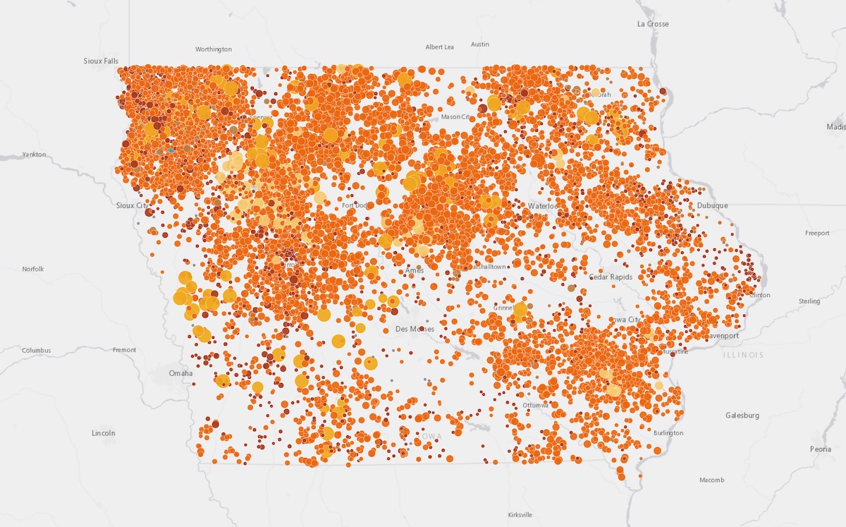
Iowa is covered in farms of all sizes. The state produces the most hogs in the country and leads in the number of egg-laying hens.
However, knowing an operation’s impact can be difficult. Even if you know where a nearby operation is, it’s hard to know exactly how many animals are found inside the facility, let alone the amount of waste being produced.
Using Iowa Department of Natural Resources data, Sentient Media was able to map nearly 11,000 livestock operations in the state. This interactive GIS map allows you to type in an address, zipcode, county or facility name to see just how many factory farms are in your backyard, as well as an estimation of the amount of manure they produce and citations from the state Department of Natural Resources (DNR).
How Do I Use This Map?
You can enter your address in the search bar to see all the factory farms within a radius of 5, 10, or 25 miles of that address. Or you can enter a ZIP code, town, or county in the search bar to see all the factory farms within that ZIP code, town, or county. You can also search for agricultural facilities by name.
Users can filter to see different types of farms based on the number and type of animals raised.
You can also use the lefthand box to filter to show farms with four types of agency actions: Notices of Violations (NOVs), Letters of Noncompliance (LNCs), Administrative Orders (Orders) and manure spills, as documented and enforced by the Iowa Department of Natural Resources. The map pulls violation data going back to 2003.
When you click on a facility, you can see in-depth details about a specific farm. The map will display a profile of the operation, the number of violation notices, the most recent violation and a link to the facility’s full Iowa Department of Natural Resources profile.
Can I See Whether Farms Are Located in Floodplains or Near Bodies of Water?
When viewing a factory farm’s profile, or when viewing the entire map if you zoom in far enough, satellite imaging shows any freshwater lakes, estuaries and rivers nearby.
This zoomed-in view also shows each facility’s distance from flood hazards and floodplains.
The location of a factory farm next to a waterway does not imply that it discharges into this waterway. Information about where Iowa’s factory farms spread their waste is not transparent, because in Iowa, factory farms’ manure application records are legally confidential. (This is not true in all states.) Instead, this mapping shows just how closely situated factory farms can be to the state’s rivers and streams.
What Do the Different Types of Violations (NOV, LNC, order, spill) Mean?
The Iowa Department of Natural Resources issues documentation to animal feeding operations when there has been pollution, mishandling of livestock or other wrongdoing on farms related to environmental and human health. Our map allows readers to filter to show farms that have experienced four different types of enforcement actions from the agency.
A Notice of Violation, or NOV, occurs when operators are notified of actual or threatened environmental harm that has occurred due to actions taken by the operator, or when a facility has repeatedly failed to return to compliance.
A Letter of Non-Compliance, or LNC, is used to address less significant, first-time offenses where there is no threat to the environment or human health.
An Administrative Order is when the Iowa DNR requests certain actions from a facility without negation and usually involves a penalty fee. These are used when emergency action is needed to remedy violations that harm the environment and human health.
A manure spill is when there is a documented case of livestock waste discharged into a waterway or other sensitive area.
These filters and categories are not an admission of wrongdoing from an operation. More complete information about violations from farms can be viewed in the compliance portal from the agency, which is built into the map.
The data for all four types of violations was scraped from the Iowa Department of Natural Resources Field Office Compliance data.
Where Did the Farm Data Come From?
The data on all farms came from the Iowa Department of Natural Resources AFO (Animal Feeding Operations) geodatabase.
We mapped operations with at least 300 “animal units”, a unit of measurement based on animal weight and size across all species. We chose to map those with 300 or more animal units because that is how the Environmental Protection Agency categorizes medium and large Concentrated Animal Feeding Operations, or CAFOs, across the country.
What’s the Difference Between Animal Units and Number of Animals?
When you click on a facility, the map displays two different numbers conveying how many animals are housed there. The first is “estimated head,” or the estimated number of animals. The second is “animal units.” An animal unit is defined by taking the number of animals on a facility and multiplying it by an “equivalency factor” outlined in an Iowa statute. It’s a measurement used in the agriculture industry to compare farms with different types of animals. For example, when looking at dairy cattle, the equivalency factor is 1.4, meaning that 1,400 dairy cattle are equal to 1,000 animal units. For mature hogs in Iowa, the equivalency factor is 0.4, so 2,500 mature hogs are equivalent to 1,000 animal units.
How Did Sentient Estimate Manure Amounts?
To estimate the rough annual manure output for CAFOs in Iowa, we used Natural Resources Conservation Service agricultural waste characteristics. Each species — hogs, cattle, chicken, turkeys, sheep, and goats — has its own estimated weight and manure output which was calculated and is displayed on the Manure tab and each facility’s individual profile.
Based on these findings, Iowa CAFOs produce an estimated 170 billion pounds of manure annually.
Hogs farms produce the largest concentration of manure in the state, accounting for nearly 60% of annual waste.
The annual manure output is an estimation. It is not an exact number, nor is it meant to reflect whether a facility listed on the map is actively mishandling animal waste. These calculations include a roughly 10–20% rate of uncertainty given the numerous factors that make up an animal’s seasonal diet, feed content, weight at the time of data collection and other factors. This map sources information from publicly available Iowa Department of Natural Resources databases and is meant to inform and educate Iowa residents, researchers, journalists and more about the scale of Iowa factory farming.
This dataset has been made available here and includes a row of estimated annual manure output for each operation, based on the animal species and units provided by the Iowa Department of Natural Resources.
More interesting manure observations based on this map can be found here.
Why Do Some Farms Have Incomplete, Odd Names or Duplicate Addresses?
Information provided by the Iowa Department of Natural Resources is often filled out directly by farm operators. Sometimes one person owns multiple facilities on the same property. In this case, the listings might be named Farmer John Site 1 and Farmer John Site 2. Sometimes operators will simply name a site a string of numbers that is relevant to its business operations and isn’t meaningful to the general public.
One operation can also have two different farm managers for two different confinements. In this case, two sites at the same address might be named Farmer John Site and Farmer Bob Site. There can also be some confinements whose permits are held by a larger company and others with the same street address that are not.
This map may display multiple points at the same street address because some farm operations have multiple permits. For example, a farmer may have one confinement operation where they raise piglets and a separate structure where hogs are “finished” or raised to slaughter. Or a farmer may have one confinement where they raise hogs and another on the same property where they raise beef cattle.
For sites with duplicate addresses, Sentient Media checked street addresses against permit information to determine whether the duplication was an error in the Iowa Department of Natural Resources source database or a site with multiple active permits.
What Is “Other” in Animal Type?
“Other” in animal type includes horses, ducks, and seafood (shrimp).
Can I Use This Map in My Publication? Can I Use These Methods to Build My Own Map?
Yes. Sentient Media is making the data and coding process behind this map freely available through GitHub here.
You are encouraged to share and cite this map and its information. If this map is cited or linked, please credit Sentient Media. You can also reach our audience team here for additional information or questions about citation, republication or collaboration.
If you believe there is an error in this map, please contact Sentient Media here.
What Can I Do if I’m an Iowan Concerned About Water Pollution or Manure Near Me?
If you would like to regularly test your tap water and a local body of water for nitrates, you can order a testing kit here from Iowa Citizens for Community Improvement.
If you get your water from a private well, you can order a water testing kit here.
You can report releases of manure or hazardous substances to the Iowa Department of Natural Resources’ 24-hour spill line: (515) 725-8694. You can also use this line to report fish kills. More guidance on spill reporting in Iowa can be found here.
What Can I Do if I Live Somewhere Else in the United States?
Iowa is not the only state with nitrate pollution. Almost 20% of Americans have high levels of nitrates in their drinking water, according to an Environmental Working Group analysis. If you would like to regularly test your tap water and a local body of water for nitrates, you can order a testing kit here from the Izaak Walton League.
Have You Been Affected by Nitrate Pollution or Manure Spills in Iowa? Let us know what happened at our end-to-end encrypted email.
Get the Scoop: Sentient will continue investigating animal agriculture and water pollution in Iowa and across the country. Sign up for our newsletter to find out when we publish more reporting.
John McCracken is an investigative reporter whose work examining the nation's consolidated meat industry, industrial agriculture and climate change has received awards and recognition from the Chicago Book Club, North American Agricultural Journalists, Wisconsin Newspaper Association, Iowa Newspaper Association and more. He has been invited to speak about his reporting at the Society for Environmental Journalists, NICAR and more.

Investigation
Elections•9 min read
News
If passed by the governor, the bill would protect farms from lawsuits surrounding their greenhouse gas emissions.
Factory Farms•4 min read

Feature
Drey’s diagnosis comes amid national attention on Iowa’s cancer crisis, which experts believe could be tied to a “toxic mix” of environmental and health risk factors.
Health•8 min read